Let It Shine: Gary Barlow to cast the Take That musical in brand new BBC One reality show

Let It Shine: Gary Barlow to cast the Take That musical in brand new BBC One reality show

Could it be magic?​
Gary Barlow has got a brand new reality show coming to BBC One - and Take That fans are going to love it.
Let It Shine - as it's currently called - will see Gary putting together the cast of a brand new Take That musical and we basically can't wait.
Over eight weeks, Gary and three mentors will be searching for stars who can live up to Take That's legacy in the stage show, which is being created in association with Mark Owen, Howard Donald and Gary himself.
Lake Saif ul Malook

Lake Saif ul Malook

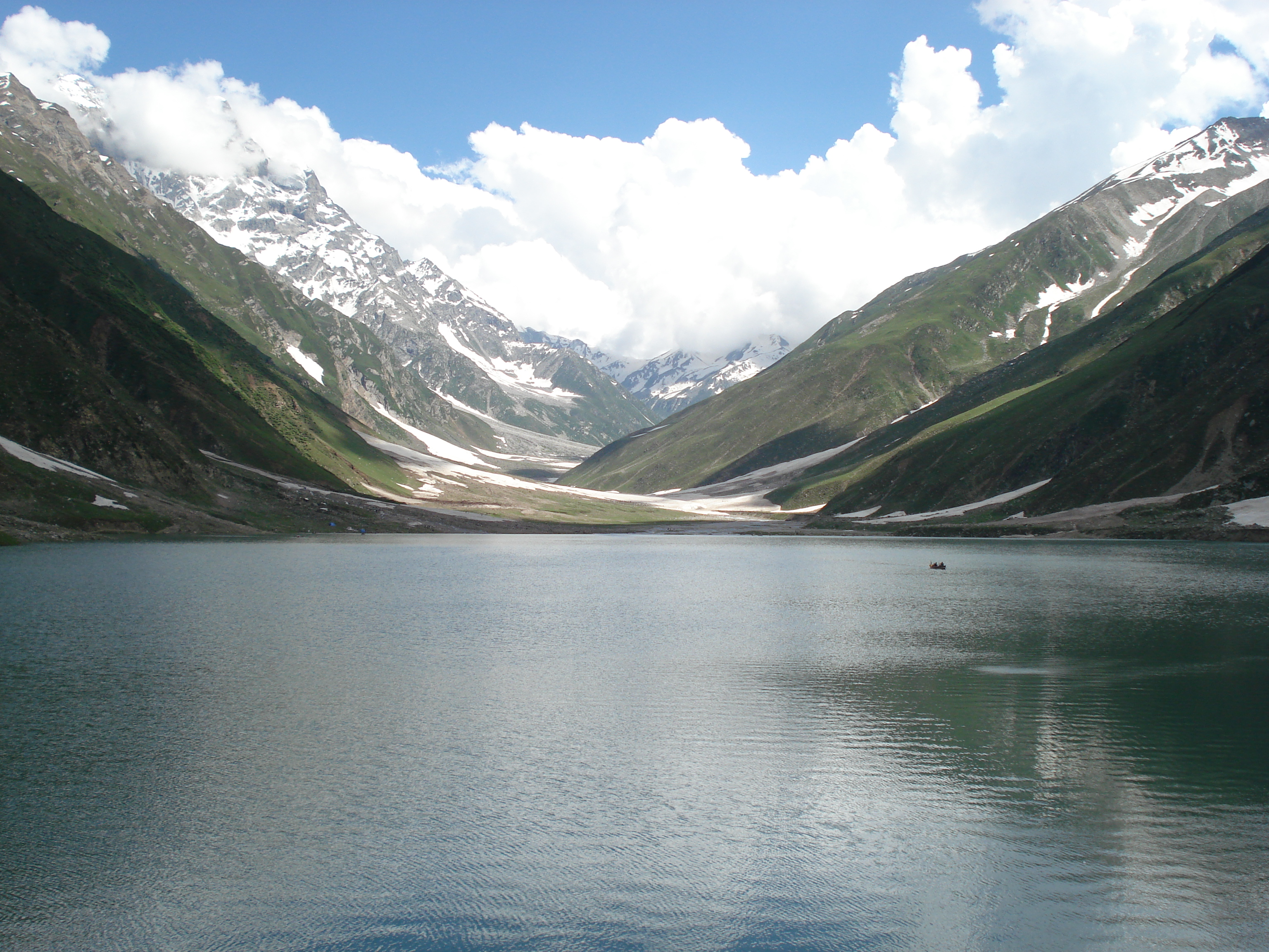
Lake Saif ul Malook is a famous tourist resort, well known for the associated story of a Persian prince Saif ul Malook. It is located about 8 kilometers (5 miles) north from the town of Naran in northern end of Kaghan Valley, in District Mansehra, Khyber Pakhtunkhwa.
The lake with its majestic and mesmerizing natural beauty, pleasant atmosphere and associated tale and history, attracts thousands of tourists each year from all around the country during the summer.
The lake is also famous for being habitat of large size Brown Trout fish, which weigh up to 7 kilograms. Lake Saif ul Malook also provides a marvelous view of Malika Parbat, which is the highest peak of Kaghan Valley.
The best time to visit Lake Saif ul Malook is between May and the end July. It remains covered in snow during winter, and the road to the lake stays closed due to heavy snow fall.

Altitude:

Lake Saif ul Malook is one of the highest alpine lakes of Pakistan. It is located at an altitude of 3,224 meters (10, 578 feet) above sea level.

Depth:

There are lots of controversies about the depth of Lake Saif ul Malook. In fact, there is no authentic source to tell the exact depth of lake. The local people of the valley say Lake Saif ul Malook is 1 kilometer deep, some of them says it is 1.7 kilometers. However, a team which recently conducted a survey on all alpine lakes of Northern Areas of Pakistan told that the depth of Lake Saif ul Malook is 50 feet.
If we take a look at figures given above, the one (50 feet) provided by the team which conducted survey seems to be more realistic, as if we consider the geography of the area surrounding the lake, it would be marvel of nature for a lake to be 1-1.7 kilometers deep at an altitude of 3 kilometers above sea level.

Story of Lake Saif ul Malook:

The classic story of Lake Saif ul Malook is written by Sufi poet Mian Muhammad Bakhsh. It is written in the form of poetic verses.
The story is about a Persian prince named Saif ul Malook who fell in love with a fairy named Badi ul Jamal (transformation in English: Glory of the moon), whom he saw in his dreams. The prince thus started his journey to find his beloved fairy Badi ul Jamal. He was clueless in his restless journey until he met a Devish (holy man), who told him how he can find her. Devish also told him that he had to go through many exams before he could find and marry Badi ul Jamal, because she was a fairy and prince was human.
The prince then starts his journey for the impossible in the name of his love. The rest of the story chronicles the challenges he faced during his journey and the spiritual lessons he learned on the way.
Map of Lake Saif-ul-Malook
Makra Peak

Makra Peak

Makra Peak is a 3586 meters (11765.feet) high Himalayan mountain located in Tehsil Balakot of Mansehra District in Khyber Pakhtunkhwa. Makra is a word of Urdu which means spider. According to local people they named it Makra Peak because snow formation over the peak resembles the shape of a spider. The iconic Makra Peak of Shogran Valley is located in south-east of Kiwai and south of Paye Meadow. A moderate 4-6 hours trek (depending on trekker fitness) from Paye leads to Makra Top. From Makra Top the visitors can enjoy the picturesque views of the Kaghan Valley on one side and mesmerizing Kashmir on another. Many other famous mountains like Malika Parbat, Chambra, Musa Ka Musalla and Shingri are also visible from top.
Makra is a simple peak to climb with a moderate level of trekking difficulty and doesn’t require any technical climbing skills or knowledge to climb it. Still deaths are reported by the local people, which I think must be due to carelessness of trekkers or severe weather.

How to reach:

About 62 km (38 miles) from the city of Mansehra on Kaghan Road comes Kiwai. From Kiwai, a single road (about 7 km) leads upward to Shogran. It is a famous tourist resort and has some motels for tourists to stay. Now comes trekking part of the trip. From Shogran you can hire jeeps, horses or ponies for the trek if you don’t prefer backpacking. A jeep can take you up to Siri. Onward from Siri foot trek starts. You can also hire ponies or horses for the rest of trek up to Makra Peak base camp if you wish. It is about 4 hours trek depending on the fitness of a trekker.

Tourist Guide & Safety Precautions:

Although Makra is a simple peak to climb but it is highly suggested to avoid climbing if weather conditions are unfavorable. Especially in stormy or foggy weather, it is very dangerous to climb the mountain.
People with with respiratory problems should avoid the trek and ascent.
K2

K2

K2 from Baltoro
K2 Mountain is the second highest mountain peak in the world and the highest peak in Pakistan. The sky-scraping mountain is also known as “Savage Mountain”, “Mount Godwin-Austen”, “Choogri” and “Mount Qogir”. It is located on the border between Baltistan in Gilgit-Baltistan region of Pakistan and Taxkorgan Tajik Autonomous Country of Xinjiang, China. Elevation of K2 is 8,611 meters( 28,251 ft).
K2 is called “Choogri” in local language. “Choogri” is a Balti word, which means “King of Mountains”. Mostly K2 is scaled from the trust worthy path that comes from Skardu. It is conventional path to scale the mountain and is used by most of mountaineers. The other path that comes from Chinese side is extremely difficult and hazardous.
The mountain was named “Savage Mountain” due to extreme difficulty of ascent and second highest fatality rate among “Eight Thousanders”. For every four people who reached the summit, one has died trying. In early days K2 witnessed many ascents and today the peak has been climbed from all sides.
In spite of extreme difficulty and hazards K2 presents; the adventure lovers from all over the world try to take new and diverse routes to conquer the mountain. K2 can be reached from the hilly town of Skardu which is well linked with Islamabad (the capital of Pakistan); both by road and air.
K2 Mountain Map

Satpara Lake

Satpara Lake (also called “Sadpara Lake”) is natural lake situated about 9 kilometers (5.59 miles) north of Skardu (the capital of Baltistan), in Gilgit-Baltistan region of Pakistan. Situated at an altitude of 2,635 meters (8645 feet) the lake is reached after 20 minutes of jeep drive from Skardu.
The lake is fed by Satpara Stream. It works as a key water supply source for the Skardu Town. It is spread over an area of 2.5 kilometers (1.55 miles). There is fairy-tale picturesque island in the center of lake. One can use a country boat to reach the island. A story about this lake is famous among local people that there is a gold mine in bottom of this lake. They believe that this is the reason why its water seems to be shining in the day time.
Satpara Lake with its marvelous and breathtaking beauty is considered one of the most charming lakes among tourists. The lake’s crystal clear waters present a marvelous and picturesque view to visitors by mirroring the icy mountains; encircled around the lake. One can do fishing, motor boating and rowing at the lake. Fishing gear, row boats and motor boats can be hired from Satpara Lake Inn. Fishing gear is very cheap to hire although cost of fishing license is US $10 for one person.
Map of Satpara Lake
Shandur

Shandur

Shandur Top situated at an altitude of 12,500 feet (38000 meters) above sea level is famous for having the highest polo ground of world. It is sometimes called Roof of the World. It is located in District Ghizer, Gilgit–Baltistan, Pakistan. The version of polo game played in Shandur Polo Ground is considered to be the purist of all. It is also called free style polo.
Polo is the most favorite game in Gilgit-Baltistan region of Pakistan. Gilgit, Skardu, Hunza, Shigar, Laspor, Mastoj, Chitral and all other valleys around must have at least one polo ground, where local people can be seen playing polo.
Shandur can be reached from Gilgit and Chitral. It is about 197 kilometers (122 miles) from Gilgit and 147 kilometers (91 miles) from Chitral. When coming from Gilgit to Shandur one can see the charming valleys of Gahkuch, Gupis, Phandar and many beautiful lakes. When coming from Chitral one can see the beauty of Mastuj and Surlasp valleys.
Shandur Polo Ground is naturally designed to be a polo ground. Small hills are on all four sides of rectangular ground, where spectators can sit and enjoy the match. The surrounding landscape and Shandur Lake makes it even more beautiful.
The beautiful polo ground of Shandur turns into a city of tents each year between 7 and 9 July due to Shandur Polo Festival. A match of polo is held between teams of Gilgit and Chitral. A great number of tourists and spectators from different areas of country especially from Hunza, Skardu and Chitral come to attend this event. Shandur Polo Ground is located at an altitude of 12,200 feet (3,700 meters) and it is very hard to play here due to reduced amount of oxygen. It requires a lot of stamina and players must be physically very strong. The match is always marvelous because cream players from Chitral and Gilgit participate in it.
Shandur Polo Festival is continuously being held each year since 1936, and it is now a very famous event for tourists throughout the world. Now activities like paragliding, folk music and dances are also held along with polo, making it even more enjoyable for tourists. PTDC and other tourism companies establish a tent village for the tourists during the event. But most of tourists bring their own camping gear. Remember to bring warm clothes because it is very cold here especially after the evening.
Map of Shandur
Gupis

Gupis

Gupis Valley is located about 112 kilometers (70 miles) in west of Gilgit on the bank of River Gilgit, in District Ghizer of Gilgit-Baltistan region, Pakistan. The 35 kilometers (22 miles) road between Gahkuch (capital of District Ghizer) and Gupis Valley is full of beautiful landscapes and breathtaking views. The turquoise water of river flowing along the road and surrounding fields and forests presents are very charming for tourists.
A few kilometers from the valley of Gupis is a charming lake called Khalti Lake. It is famous for being habitat of trout fish. The lake is formed due to stretch of river near the village of Khalti. The dark blue waters of lake during summer look very charming. The lake usually freezes during winter and villagers of Khalti use to walk on this. There is beautiful restaurant near the Khalti Lake. A PTDC motel is situated nearby to facilitate tourists.
Phandar Valley

Phandar Valley

Phandar Valley is situated 61 kilometers (38 miles) from the valley of Gupis, in District Ghizer of Gilgit-Baltistan, Pakistan. A twisting road passing through lush green fields and forests with a view of flowing river and icy peaks will lead you to this charming valley. From springs of crystal clear waters to lakes and rivers of deep blue water, there are all colors of nature’s beauty in Phandar Valley. The very first glance of this valley will eleminate all fatigue of journey and will reenrgise you with its mesmarising views. Peaceful deep blue waters of River Ghizer and surrounding lush green and golden fields are breathtaking.
Weather of Phandar valley stays very pleasant between June and July and this is the best time to visit this valley because the beauty of this valley goes at its peak during these months. Days stays fair and warm and nights are a little cold.
A motel of PTDC is situated at a small hill beside the road to facilitate tourists. The view of Phandar Lake is masmerizing for visitors. Area of Phandar Lake is about 3 kilometers.
Fairy Meadows

Fairy Meadows


Fairy Meadows famous for its beautiful lush green plateaus and World’s ninth biggest mountain Nanga Parbat (the Killer Mountain) is located in Diamer District of Gilgit-Baltistan region, Pakistan. The place was named Fairy Meadows in 1953 by an Australian climber Hermann Bhul due to its mesmerizing beauty. He was here to climb the peak of Nanga Parbat. He became the first one to summit the mountain. Fairy Meadows is also called “Heaven on Earth” due to its matchless beauty.

Overview:

A night camping or stay in traditionally constructed wooden cottage at Fairy Meadows with a breathtaking view of mighty Nanga Parbat’s North face is very unique and wonderful experience. Even more if sky is clear and night is full moon. The cool moonlight reflecting from the gigantic majestic icy peak shows the real meaning of nature’s beauty and peace.

How to reach?

The first stop near Fairy Meadows is Raikot Bridge. It is located at an altitude of 4595 feet (1400 meters) above sea level and about 540 kilometers (336 miles) from Islamabad (the capital of Pakistan), when coming through Karakoram Highway.
From Raikot Bridge you can hire a local jeep to reach Tatoo Village at an altitude of 9515 feet (2900 meters) above sea level. It will take about half hour of exciting journey to reach Tatoo Village.
Onwards from Tattu route becomes too narrow for a jeep to travel but not very difficult for trekking. After two to three hours of trekking depending on your fitness level, you’ll reach Fairy Meadows.

Where to stay?

There are several hotels and tourist lodges are available to facilitate tourists in Fairy Meadows. Most of them of are available at very reasonable prices. A few although are little expensive. Many tourists like to stay in camps on grassy places.
Food is expensive here as compared to cities. But availability of food at this remote place makes it worth paying.

When to visit?

The best time to visit Fairy Meadows is between end of June and middle of August. The place becomes inaccessible in winter due to heavy snowfall.

Fairy Meadows

Astola Island

Astola Island also called Astole is situated is Balochistan Province of Pakistan. It is also known as ‘Jezira Haft Talar’ or ‘Island of the seven Hills. It is an uninhabited island in the Arabian Sea. The Island is a part of Pasni sub-district of Gwadar District.
The island is 6.7 kilometres in length and a maximum width of 2.3 kilometres. The highest point of the island is 246 feet above sea level. Astola Island maintains endemic life because of its isolated location. It is a very important area for endemic life. It is also support a large number of breeding water birds and many other creatures. There is no source of fresh water on the island. That is the reason that there are no trees on the island. The vegetation depends on the occasional rainfall and soil moisture for survival.
In the Astola Island there is a small mosque associated with Khawaja Khizr and there are ruins of an ancient Hindi temple of Hindu goddess ‘Kali’. The island was called Satadip among Hindus.
Astola is a popular but hard destination for tourism due to the lack of lodging facilities. Tourists who are willing to stay overnight must bring their own provisions and camp on the island. Scuba diving, fishing and camping expeditions are popular.
Map of Astola Island
Punnu Fort

Punnu Fort

The ruins of Punnu Fort (also called Punnu’s Fort) are sited about 15km from Turbat, a city in southern part of Balochistan. According to archaeologists Punnu Fort could date back to 6000-8000 BC.
Punnu was a local prince of this area who was port of the “Sassi Punnu” romance which is famous in Makran and Sindh yet, even; thousands of years have been passed. Sassi Punnu (or Sassui Punnhun) love is one the seven popular tragic romances from Sindh and Balochistan.
The fort looks like it would have been small and possibly made of mud and stones. There are vantage points where one could see quite distance accross Turbats plains to the Makran mountain ranges. The remains of Punnu Fort, surrounded by date trees on a high ground can be a good picnic point in a nice weather.
Map of Punnu Fort
Pishin Valley

Pishin Valley


Pishin Valley is about 50 kilometers from Quetta city in District Pishin in the northwest of Balochistan province of Pakistan. It consists of thousands of acres of fruit orchards. The valley is a fertile land where several crops and fruits are grown. Pishin Valley is renowned for the greenery and is also the primary place for crop production. Besides the crops it is also famous for the growth of vegetables and fodder. Today Pishin Valley is famous for horticulture and agriculture in Pakistan.

Apart from the fruit, there is a quaint little market town which is famous for eating joints and other traditional foods. There is a man made spring ‘Karez’. This artificial spring is made in order to use the subterranean water for irrigation purposes.


The Pishin Valley is a center of festivity and colorful harvest programs and other cultural fetes. Folk dances are very popular. In spring when most of the plants are in bloom, it gives a splash of colour to Pishin Valley. Migrant tribesmen travel across the valley in autumn and spring with their herds of sheep and camels and their assorted wares for sale. This seasonal movement adds colour and beauty to the life of Pishin Valley.


In recent years Pishin Valley has become one of the important tourist attractions in Balochistan. There lies Bund Khushdil Khan. Bund Khushdil Khan is a 5km long and 2km wide tank and is one of the wonderful sights. It is entirely dependent on rainfall and snow. Today it has become a spot of duck shooting.

In Pishin Valley tourists can participate in activities like horse jumping, trick horse riding, trick motor cycle riding and dare-devil motor car driving .There is also a dog and hare race which is an important event especially during the harvesting festival. There is a fortress nearby and when sun sets the fortress looks splendid. In short Pishin is a full of life and beautiful place to be visited.

Map of Pishin Valley
Mehrgarh

Mehrgarh


Mehrgarh is a Neolithic site (7000 BCE to c. 2500 BCE) located 30 kilometers (18.64 miles) west of the town of Sibi and 120 kilometers (74.57 miles) south-east of Quetta on the Kachi plain of Balochistan, Pakistan. It is one of the oldest sites with evidence of agricultural activities in Asia. Evidence of farming (wheat and barley) and herding (sheep, goats and cattle) have been discovered in the area. The discovery of Mehrgarh was made in 1974 by and archaeological team supervised by French archaeologist named Jean-François Jarrige. The place was continuously excavated between 1974 and 1986, and again from 1997 to 2000.
The earliest settlement in Mehrgarh is found at north-east corner, is dated between 7000 BCE to 5500 BCE. It was small agricultural village of 495 acre (2 square kilometers). The entire area covers several subsequent settlements. Archaeological materials have been found in six mounds. About 32000 art crafts have been discovered in this area. Mehrgarh is now conceived as forerunner to Civilization of Indus Valley.

Map of Mehrgarh

Kategori

Kategori